 1. Flood Mapping in Cameroon.In September 2012 Northern part of Cameroon was hit by sever floods. International Charter “Space and Major Disasters” was activated to acquire satellite images over affected regions. UN-SPIDER Regional Support Office in Ukraine (Space Research Institute NASU-NSAU), State Space Agency of Ukraine (SSAU) and Center of the Special Information Receiving and Processing and the Navigating Field Control (CSIRP and NFC) coordinated their efforts in order operationally acquire images from the Ukrainian remote sensing satellite Sich-2 and deliver maps of flood waters.
 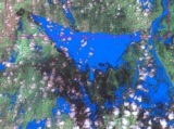 The following images were acquired:
• 10 September 2012 over city of Maga;
• 15 September 2012 over city of Garoua.
The following images were acquired:
• 10 September 2012 over city of Maga;
• 15 September 2012 over city of Garoua.
Thematic processing and mapping of Sich-2 data was carried out by the CSIRP and NFC. These maps were further translated in English and delivered to the Charter Project Manager and posted to the Charter Web-site.
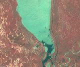 2. Flood Risk Assessment in Ukraine. In early spring 2012 the ice on the Kyiv reservoir could provide damages to the dam and hydroplant. The average ice depth was ~40 cm. Within international collaboration of Space Research Institute NASU-NSAU and UN-SPIDER Regional Support Office with the National Aeronautics and Space Administration (NASA) Sich-2 and EO-1 images over the Kyiv area were acquired on 17 March 2012. Availability of the two synchronous images allows cross-validation to be carried.