 1. Crop Mapping. Crop identification and mapping is a key component of agriculture monitoring. Sich-2 data in fusion with data acquired from other sensors (ЕО-1, Landsat-5) were used for crop mapping: winter cereals, winter rapeseed, and spring crops. Comparison of the derived crop maps with information on the parcels allows identification of potential unauthorized sowings, in particular rapeseed. Service and products are developed within collaboration with the The State Science-Technological Centre of Soil Fertility Protective of the Ministry of Agrarian Policy and Food of Ukraine, and Ukrainian Hydrometeorological Center.
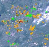 2. Crop rotation identification.Different satellite data were used for mapping rapeseed in 2011 and 2012, and identifying parcels failing to conform to crop rotation rules for winter rapeseed. The data used are Sich-2, ЕО-1, Landsat-5 and Landsat-7.
Ground surveys were conducted in May 2012 for classification of satellite imagery and validation of the developed products. Visual photointerpretation was carried out as well. The produced thematic maps show parcels with winter rapeseed in 2011 and 2012 and parcels potentially failing to conform to crop rotation rules. Service and products are developed within collaboration with the The State Science-Technological Centre of Soil Fertility Protective of the Ministry of Agrarian Policy and Food of Ukraine.
2. Crop rotation identification.Different satellite data were used for mapping rapeseed in 2011 and 2012, and identifying parcels failing to conform to crop rotation rules for winter rapeseed. The data used are Sich-2, ЕО-1, Landsat-5 and Landsat-7.
Ground surveys were conducted in May 2012 for classification of satellite imagery and validation of the developed products. Visual photointerpretation was carried out as well. The produced thematic maps show parcels with winter rapeseed in 2011 and 2012 and parcels potentially failing to conform to crop rotation rules. Service and products are developed within collaboration with the The State Science-Technological Centre of Soil Fertility Protective of the Ministry of Agrarian Policy and Food of Ukraine.
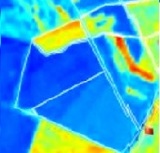 3. JECAM Test Site. GEO JECAM (Joint Experiment of Crop Assessment and Monitoring) aims to reach a convergence of approaches, develop monitoring and reporting protocols and best practices for a variety of global agricultural systems.
A network of JECAM test sites was established in Ukraine. One of such test sites is established in National University of Life and Environmental Sciences of Ukraine (NUBiP). Extensive ground measurements and detailed maps are used to validate thematic maps derived from Sich-2 satellite.
3. JECAM Test Site. GEO JECAM (Joint Experiment of Crop Assessment and Monitoring) aims to reach a convergence of approaches, develop monitoring and reporting protocols and best practices for a variety of global agricultural systems.
A network of JECAM test sites was established in Ukraine. One of such test sites is established in National University of Life and Environmental Sciences of Ukraine (NUBiP). Extensive ground measurements and detailed maps are used to validate thematic maps derived from Sich-2 satellite.