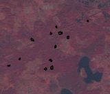
 Forest Clear-cuts in Shatsk National Natural Park. Sich-2 data along with data derived from other remote sensing sensors (Landsat-5) were used for identification of potential clear-cuts with the territory of the Shatsk National Natural Park (NNP). Methods and technologies of the European Commission on land cover and land use mapping using satellite and in situ data were adapted for Ukraine. Land cover maps for 2010 and 2011 were produced, and analysis of changes in forest cover allowed us to identify potential clear-cuts within Shatsk NNP. Service and products are developed within the project of Ministry of Ecology and Natural Resources of Ukraine on creation of system of environmental monitoring using satellite data.